
Make a donation
Gear up for your next adventure:
As an Amazon Associate, this site earns from qualifying purchases at no extra cost to you.
Yan'an topographic map
Click on the map to display elevation.
Make a donation
Gear up for your next adventure:
As an Amazon Associate, this site earns from qualifying purchases at no extra cost to you.
Yan'an
Yan'an is located in northern Shaanxi on the Loess Plateau, with a latitude spanning from 35°21′ to 37°31′ N, and a longitude spanning from 107°41′ t0 110°31′ E. The city is bordered by Yulin to the north, Xianyang, Tongchuan, and Weinan in the Guanzhong region to the south, Linfen and Lüliang of Shanxi to the east across the Yellow River, and Qingyang of Gansu to the west across the Ziwu Ridge (Chinese: 子午岭). The city's elevation is hilly, and is higher in the northwest, and lower in the southeast, ranging from 388 metres (1,273 ft) to 1,809 metres (5,935 ft) above sea level in elevation. The average elevation of Yan'an is approximately 1,000 m (3,280 ft), and Yan'an's urban core has an elevation of about 960 metres (3,150 ft) above sea level. In addition to the Yellow River flowing through Yan'an, the city's major rivers include the Yan River and the Luo River.
Make a donation
Gear up for your next adventure:
As an Amazon Associate, this site earns from qualifying purchases at no extra cost to you.
About this map
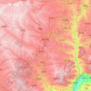
Name: Yan'an topographic map, elevation, terrain.
Location: Yan'an, Shaanxi, China (35.35145 107.65051 37.49958 110.54643)
Average elevation: 3,891 ft
Minimum elevation: 1,165 ft
Maximum elevation: 5,968 ft
Make a donation
Gear up for your next adventure:
As an Amazon Associate, this site earns from qualifying purchases at no extra cost to you.
Other topographic maps
Click on a map to view its topography, its elevation and its terrain.
Xi'an
China > Shaanxi > Weiyang District > Xi'an
Xi'an lies on the Guanzhong Plain in the south-central part of Shaanxi province, on a flood plain created by the eight surrounding rivers and streams. The city has an average elevation of 400 metres (1,312 ft) above sea level and an annual precipitation of 553 mm (21.8 in). The urban area of Xi'an is located…
Average elevation: 1,352 ft
Make a donation
Gear up for your next adventure:
As an Amazon Associate, this site earns from qualifying purchases at no extra cost to you.
Huanglong
Huanglong County is located approximately 221 kilometres (137 mi) from Yan'an's urban core, and 226 kilometres (140 mi) from Xi'an's urban core. Located in the Loess Plateau, Huanglong County is hilly in elevation, ranging from 643.7 metres (2,112 ft) to 1,738 metres (5,702 ft) in height. A number of minor…
Average elevation: 4,423 ft
Make a donation
Gear up for your next adventure:
As an Amazon Associate, this site earns from qualifying purchases at no extra cost to you.
Make a donation
Gear up for your next adventure:
As an Amazon Associate, this site earns from qualifying purchases at no extra cost to you.