Geolocate

Hugom topographic map

Click on the map to display elevation.

About this map

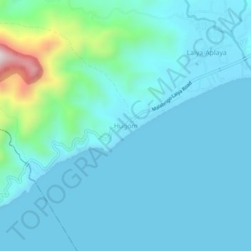
Name: Hugom topographic map, elevation, terrain.

Location: Hugom, San Juan, Batangas, Calabarzon, Philippines (13.64431 121.35433 13.68431 121.39433)

Average elevation: 249 ft

Minimum elevation: 0 ft

Maximum elevation: 1,939 ft

Gear up for your next adventure:

📦Gear Storage Bags - Organize and protect outdoor equipment
🪓Survival Multi‑Tool - Versatile tool for camp and trail tasks
🎒Waterproof Dry Bags - Keep your electronics and maps dry inside your pack
🧤Tactile Hiking Gloves - Keep hands warm while operating GPS and smartphone screens
🛌Ultralight Sleeping Bags - Compact down bags for cold nights in the wilderness

As an Amazon Associate, this site earns from qualifying purchases at no extra cost to you.