
Thank you for supporting this site ❤️
Make a donation
Make a donation
Gear up for your next adventure:
As an Amazon Associate, this site earns from qualifying purchases at no extra cost to you.
Acacías topographic map
Click on the map to display elevation.
Thank you for supporting this site ❤️
Make a donation
Make a donation
Gear up for your next adventure:
As an Amazon Associate, this site earns from qualifying purchases at no extra cost to you.
About this map
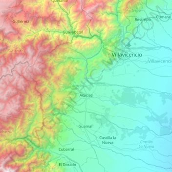
Name: Acacías topographic map, elevation, terrain.
Location: Acacías, Piedemonte, Meta, Orinoquia, 507001, Colombia (3.84189 -74.03708 4.20289 -73.41766)
Average elevation: 4,019 ft
Minimum elevation: 906 ft
Maximum elevation: 13,648 ft
Thank you for supporting this site ❤️
Make a donation
Make a donation
Gear up for your next adventure:
As an Amazon Associate, this site earns from qualifying purchases at no extra cost to you.