
Butler topographic map
Click on the map to display elevation.
About this map
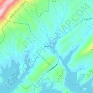
Name: Butler topographic map, elevation, terrain.
Average elevation: 2,201 ft
Minimum elevation: 1,932 ft
Maximum elevation: 3,435 ft
Johnson County trails, hiking, mountain biking, running and outdoor activities
Other topographic maps
Click on a map to view its topography, its elevation and its terrain.
Mountain City
United States > Tennessee > Johnson County
Mountain City is a town in and the county seat of Johnson County, Tennessee, United States. The population was 2,383 at the 2000 census and 2,531 at the 2010 census. It is the northeasternmost county seat in Tennessee. In addition, at an elevation of 2,418 feet (737 m), it has the distinction of being the…
Average elevation: 2,713 ft