
Thank you for supporting this site ❤️
Make a donation
Make a donation
Gear up for your next adventure:
As an Amazon Associate, this site earns from qualifying purchases at no extra cost to you.
Taxco topographic map
Click on the map to display elevation.
Thank you for supporting this site ❤️
Make a donation
Make a donation
Gear up for your next adventure:
As an Amazon Associate, this site earns from qualifying purchases at no extra cost to you.
About this map
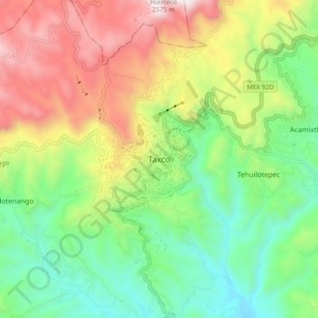
Name: Taxco topographic map, elevation, terrain.
Location: Taxco, Taxco de Alarcón, Guerrero, 40200, Mexico (18.51654 -99.64528 18.59654 -99.56528)
Average elevation: 5,879 ft
Minimum elevation: 4,255 ft
Maximum elevation: 8,369 ft
Thank you for supporting this site ❤️
Make a donation
Make a donation
Gear up for your next adventure:
As an Amazon Associate, this site earns from qualifying purchases at no extra cost to you.