
Thank you for supporting this site ❤️
Make a donation
Make a donation
Gear up for your next adventure:
As an Amazon Associate, this site earns from qualifying purchases at no extra cost to you.
Route des Granges topographic map
Click on the map to display elevation.
Thank you for supporting this site ❤️
Make a donation
Make a donation
Gear up for your next adventure:
As an Amazon Associate, this site earns from qualifying purchases at no extra cost to you.
About this map
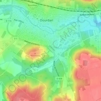
Name: Route des Granges topographic map, elevation, terrain.
Average elevation: 387 ft
Minimum elevation: 276 ft
Maximum elevation: 531 ft
Thank you for supporting this site ❤️
Make a donation
Make a donation
Gear up for your next adventure:
As an Amazon Associate, this site earns from qualifying purchases at no extra cost to you.
Other topographic maps
Click on a map to view its topography, its elevation and its terrain.
Château de Dourdan
France > Île-de-France > Essonne > Dourdan
Le château se situe au creux de la vallée de l'Orge à moins de deux cents mètres au nord du lit de la rivière et à environ cent mètres d'altitude sur un terrain argileux.
Average elevation: 404 ft