
Make a donation
Gear up for your next adventure:
As an Amazon Associate, this site earns from qualifying purchases at no extra cost to you.
Wantage Township topographic map
Click on the map to display elevation.
Make a donation
Gear up for your next adventure:
As an Amazon Associate, this site earns from qualifying purchases at no extra cost to you.
About this map
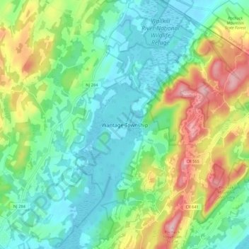
Name: Wantage Township topographic map, elevation, terrain.
Average elevation: 627 ft
Minimum elevation: 371 ft
Maximum elevation: 1,184 ft
Sussex County trails, hiking, mountain biking, running and outdoor activities
Make a donation
Gear up for your next adventure:
As an Amazon Associate, this site earns from qualifying purchases at no extra cost to you.
Other topographic maps
Click on a map to view its topography, its elevation and its terrain.
Stokes State Forest
United States > New Jersey > Sussex County
The pavilion at the top of the peak makes a great place to picnic. To make traveling to Sunrise more interesting, one can look for the New Jersey shaped rock. The mountain is the second highest point in New Jersey, being 1,653 feet (504 m) above sea level. Hikers are amazed with the view. There is a USGS…
Average elevation: 853 ft
Make a donation
Gear up for your next adventure:
As an Amazon Associate, this site earns from qualifying purchases at no extra cost to you.
Sparta Mountain Wildlife Management Area
United States > New Jersey > Sussex County > Sparta Township
Average elevation: 1,024 ft
Make a donation
Gear up for your next adventure:
As an Amazon Associate, this site earns from qualifying purchases at no extra cost to you.
Lake Neepaulin
United States > New Jersey > Sussex County > Wantage
Lake Neepaulin is a man-made lake created from the damming of Neepaulakating Creek, a small mountain stream that was not named until 2002. The creek's headwaters are located approximately 0.4 miles (0.64 km) northwest of the north end of Lake Neepaulin. These headwaters are located a short distance south of…
Average elevation: 564 ft