
Fairview topographic map
Click on the map to display elevation.
About this map
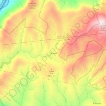
Name: Fairview topographic map, elevation, terrain.
Location: Fairview, Macon County, North Carolina, United States (35.26120 -83.65267 35.30120 -83.61267)
Average elevation: 3,255 ft
Minimum elevation: 1,893 ft
Maximum elevation: 4,242 ft
Macon County trails, hiking, mountain biking, running and outdoor activities
Other topographic maps
Click on a map to view its topography, its elevation and its terrain.
Little Tennessee River
United States > North Carolina > Macon County > Franklin > East Franklin
Average elevation: 2,103 ft