
Thank you for supporting this site ❤️
Make a donation
Make a donation
Gear up for your next adventure:
As an Amazon Associate, this site earns from qualifying purchases at no extra cost to you.
Durandi topographic map
Click on the map to display elevation.
Thank you for supporting this site ❤️
Make a donation
Make a donation
Gear up for your next adventure:
As an Amazon Associate, this site earns from qualifying purchases at no extra cost to you.
About this map
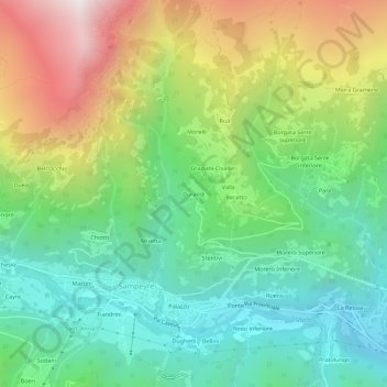
Name: Durandi topographic map, elevation, terrain.
Location: Durandi, Sampeyre, Cuneo, Piëmont, Italië (44.56918 7.17723 44.60918 7.21723)
Average elevation: 4,485 ft
Minimum elevation: 2,766 ft
Maximum elevation: 7,579 ft
Thank you for supporting this site ❤️
Make a donation
Make a donation
Gear up for your next adventure:
As an Amazon Associate, this site earns from qualifying purchases at no extra cost to you.