
Make a donation
Gear up for your next adventure:
As an Amazon Associate, this site earns from qualifying purchases at no extra cost to you.
Monte Sano Mountain topographic map
Click on the map to display elevation.
Make a donation
Gear up for your next adventure:
As an Amazon Associate, this site earns from qualifying purchases at no extra cost to you.
Monte Sano Mountain
The top is relatively flat and lies just under 500 meters above sea level. This elevation is about 300 meters higher than the floor of the Tennessee Valley, which surrounds it. A residential neighborhood occupies the western portion of the top. The eastern portion and slopes of the mountain are occupied by Monte Sano State Park. Monte Sano is connected to Round Top (Burritt) Mountain by a col to the south.
Make a donation
Gear up for your next adventure:
As an Amazon Associate, this site earns from qualifying purchases at no extra cost to you.
About this map
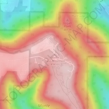
Name: Monte Sano Mountain topographic map, elevation, terrain.
Average elevation: 1,299 ft
Minimum elevation: 725 ft
Maximum elevation: 1,654 ft
Madison County trails, hiking, mountain biking, running and outdoor activities
Make a donation
Gear up for your next adventure:
As an Amazon Associate, this site earns from qualifying purchases at no extra cost to you.
Other topographic maps
Click on a map to view its topography, its elevation and its terrain.
Make a donation
Gear up for your next adventure:
As an Amazon Associate, this site earns from qualifying purchases at no extra cost to you.