
Maynard topographic map
Click on the map to display elevation.
Maynard
According to the United States Census Bureau, Maynard has a total area of 5.4 square miles (13.9 km2), of which 5.2 square miles (13.6 km2) is land and 0.1 square miles (0.3 km2), or 2.42%, is water. Average elevation is roughly 200 feet (~61 m) above sea level; the highest point is Summer Hill, elevation 358 feet (109.1 m); the lowest is the Maynard/Acton border next to the Assabet River, at 145 feet (44.2 m).
About this map
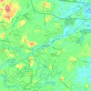
Name: Maynard topographic map, elevation, terrain.
Average elevation: 210 ft
Minimum elevation: 108 ft
Maximum elevation: 449 ft
Middlesex County trails, hiking, mountain biking, running and outdoor activities
Other topographic maps
Click on a map to view its topography, its elevation and its terrain.
Ashby
United States > Massachusetts > Middlesex County
Mount Watatic was also once home to state fire tower #31 that looked out over central Massachusetts at an elevation above sea level of 1590 FT. Phone lines to the tower ran up the Ashby and Ashburnham sides of the mountain over the years.
Average elevation: 869 ft
Waitts Mount
United States > Massachusetts > Middlesex County > Malden > Malden Centre
Average elevation: 72 ft
Hopkinton Reservoir
United States > Massachusetts > Middlesex County > Hopkinton
Average elevation: 364 ft
Bridge Meadow Brook
United States > Massachusetts > Middlesex County > Tyngsborough
Average elevation: 197 ft
Lake Mascuppic
United States > Massachusetts > Middlesex County > Tyngsborough > Willowdale
Average elevation: 187 ft
Freeman Lake
United States > Massachusetts > Middlesex County > Chelmsford > North Chelmsford
Average elevation: 131 ft
Memorial Beach
United States > Massachusetts > Middlesex County > Marlborough
Average elevation: 315 ft