
Make a donation
Gear up for your next adventure:
As an Amazon Associate, this site earns from qualifying purchases at no extra cost to you.
Gammelsbach topographic map
Click on the map to display elevation.
Make a donation
Gear up for your next adventure:
As an Amazon Associate, this site earns from qualifying purchases at no extra cost to you.
Gammelsbach
Gammelsbach liegt im Odenwald südlich von Beerfelden im Gammelsbachtal. Die Gemarkung erstreckt sich zwischen den Kammlinien der Hirschhorner Höhe im Westen und der Sensbacher Höhe im Osten. Durch den Ort verläuft die Bundesstraße 45.
Make a donation
Gear up for your next adventure:
As an Amazon Associate, this site earns from qualifying purchases at no extra cost to you.
About this map
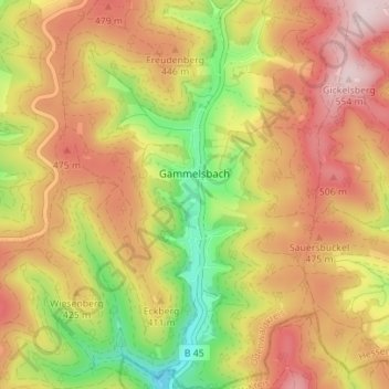
Name: Gammelsbach topographic map, elevation, terrain.
Location: Gammelsbach, Oberzent, Odenwaldkreis, Hessen, Deutschland (49.50141 8.93729 49.54661 8.99196)
Average elevation: 1,312 ft
Minimum elevation: 679 ft
Maximum elevation: 1,844 ft
Make a donation
Gear up for your next adventure:
As an Amazon Associate, this site earns from qualifying purchases at no extra cost to you.