
Make a donation
Gear up for your next adventure:
As an Amazon Associate, this site earns from qualifying purchases at no extra cost to you.
Plasselb topographic map
Click on the map to display elevation.
Make a donation
Gear up for your next adventure:
As an Amazon Associate, this site earns from qualifying purchases at no extra cost to you.
Plasselb
Die Fläche des 18,1 km² grossen Gemeindegebiets umfasst einen Abschnitt der Freiburger Voralpen. Der nördlichste Gemeindeteil wird von der Mulde von Plasselb zwischen der Ärgera im Westen und dem Sensetal im Osten eingenommen. Diese Talmulde wird im Norden von den Höhen von Lantershubel (1024 m ü. M.) und Oberholz begrenzt. Westlich schliesst das Tal der Ärgera an, das einen bis zu 400 m breiten flachen Talboden besitzt und mit Erosionsmaterial (Geröll, Sand) aus dem Einzugsgebiet aufgefüllt und teilweise bewaldet ist. In diesem nördlichen Gemeindebereich wird die westliche Grenze vom Muelersbach, einem linken Seitenbach der Ärgera, gebildet.
Make a donation
Gear up for your next adventure:
As an Amazon Associate, this site earns from qualifying purchases at no extra cost to you.
About this map
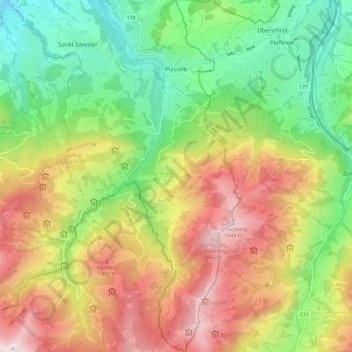
Name: Plasselb topographic map, elevation, terrain.
Location: Plasselb, Sensebezirk, Freiburg, 1737, Schweiz (46.67142 7.19292 46.75092 7.27291)
Average elevation: 3,698 ft
Minimum elevation: 2,293 ft
Maximum elevation: 5,518 ft
Make a donation
Gear up for your next adventure:
As an Amazon Associate, this site earns from qualifying purchases at no extra cost to you.