Geolocate

Sandridge topographic map

Click on the map to display elevation.

👉 Easily get elevation data in JSON, GeoTIFF and KML formats using Elevation API
Thank you for supporting this site ❤️
Make a donation

About this map

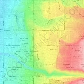
Name: Sandridge topographic map, elevation, terrain.

Location: Sandridge, Sandy, Salt Lake County, Utah, 84094, United States (40.55495 -111.86799 40.59495 -111.82799)

Average elevation: 4,728 ft

Minimum elevation: 4,501 ft

Maximum elevation: 5,003 ft

Salt Lake County trails, hiking, mountain biking, running and outdoor activities

Gear up for your next adventure:

🛏️Cold Weather Sleeping Bag - Warm sleeping bag for cold conditions
📌Outdoor GPS Map App - Apps and devices for digital topographic navigation
🛡️Bear Spray Outdoor - Protection in bear country hikes
🌧️Backpack Rain Cover - Keep gear dry in wet weather
GPS Sports Watch - GPS watch for running, hiking and training

As an Amazon Associate, this site earns from qualifying purchases at no extra cost to you.