Geolocate

Atto topographic map

Click on the map to display elevation.

About this map

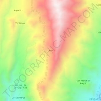
Name: Atto topographic map, elevation, terrain.

Location: Atto, Paras, Cangallo, Ayacucho, Peru (-13.53709 -74.78658 -13.49709 -74.74658)

Average elevation: 13,438 ft

Minimum elevation: 11,821 ft

Maximum elevation: 15,007 ft

Gear up for your next adventure:

📶Satellite Messenger - Communication device off‑grid
🧷Carabiner Set - Durable clips for gear attachment
🎒Gear Packing Cubes - Organize your backpack efficiently
🎒Outdoor Daypacks - Lightweight backpacks designed for carrying maps and essential gear
📚USA Hiking Guide Books - Top trail guides and map books

As an Amazon Associate, this site earns from qualifying purchases at no extra cost to you.