
Make a donation
Gear up for your next adventure:
As an Amazon Associate, this site earns from qualifying purchases at no extra cost to you.
Daoli District topographic map
Click on the map to display elevation.
Make a donation
Gear up for your next adventure:
As an Amazon Associate, this site earns from qualifying purchases at no extra cost to you.
About this map
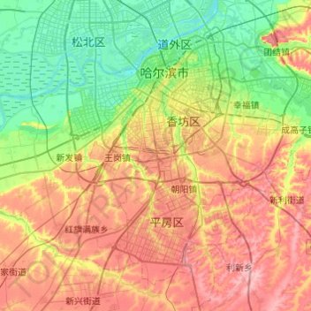
Name: Daoli District topographic map, elevation, terrain.
Location: Daoli District, Harbin, Heilongjiang, 150000, China (45.54751 126.14368 45.78716 126.62906)
Average elevation: 512 ft
Minimum elevation: 367 ft
Maximum elevation: 705 ft
Make a donation
Gear up for your next adventure:
As an Amazon Associate, this site earns from qualifying purchases at no extra cost to you.
Other topographic maps
Click on a map to view its topography, its elevation and its terrain.
Amur
China > Heilongjiang > Fuyuan City > Fuyuan
The river rises in the hills in the western part of Northeast China at the confluence of its two major affluents, the Shilka and the Argun (or Ergune), at an elevation of 303 metres (994 ft). It flows east forming the border between China and Russia, and slowly makes a great arc to the southeast for about 400…
Average elevation: 151 ft
Mudanjiang
It also borders Russia's Primorsky Krai to the east. The average elevation in the prefecture is 230 meters (755 ft), with the terrain primarily consisting of mountains and hills. The east of the prefecture begins to ascend to the Changbai Mountains, while the central parts belong to the Hegu Basin. The lowest…
Average elevation: 1,168 ft
Make a donation
Gear up for your next adventure:
As an Amazon Associate, this site earns from qualifying purchases at no extra cost to you.
Make a donation
Gear up for your next adventure:
As an Amazon Associate, this site earns from qualifying purchases at no extra cost to you.
Make a donation
Gear up for your next adventure:
As an Amazon Associate, this site earns from qualifying purchases at no extra cost to you.
Make a donation
Gear up for your next adventure:
As an Amazon Associate, this site earns from qualifying purchases at no extra cost to you.
Make a donation
Gear up for your next adventure:
As an Amazon Associate, this site earns from qualifying purchases at no extra cost to you.
Make a donation
Gear up for your next adventure:
As an Amazon Associate, this site earns from qualifying purchases at no extra cost to you.
Make a donation
Gear up for your next adventure:
As an Amazon Associate, this site earns from qualifying purchases at no extra cost to you.