Geolocate

Lillois-Witterzée topographic map

Interactive map

Click on the map to display elevation.

About this map

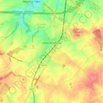
Name: Lillois-Witterzée topographic map, elevation, terrain.

Location: Lillois-Witterzée, Braine-l'Alleud, Nivelles, Brabant wallon, Wallonie, 1428, Belgique (50.62594 4.33019 50.65819 4.40473)

Average elevation: 446 ft

Minimum elevation: 315 ft

Maximum elevation: 554 ft

Other topographic maps

Click on a map to view its topography, its elevation and its terrain.

Cours d'Eau

Belgique > Brabant wallon > Nivelles > Braine-l'Alleud

Average elevation: 453 ft

Culot

Belgique > Brabant wallon > Nivelles > Braine-l'Alleud

Average elevation: 341 ft

Paudure

Belgique > Brabant wallon > Nivelles > Braine-l'Alleud

Average elevation: 322 ft

Odeghien

Belgique > Brabant wallon > Nivelles > Braine-l'Alleud

Average elevation: 328 ft

La Neuville

Belgique > Brabant wallon > Nivelles > Braine-l'Alleud

Average elevation: 354 ft