
Arambag topographic map
Interactive map
Click on the map to display elevation.
About this map
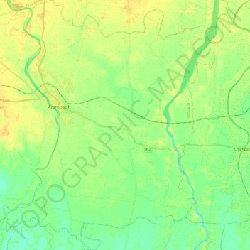
Name: Arambag topographic map, elevation, terrain.
Location: Arambag, Hugli, West Bengal, India (22.74951 87.73684 22.97100 87.94142)
Average elevation: 49 ft
Minimum elevation: 13 ft
Maximum elevation: 85 ft
Other topographic maps
Click on a map to view its topography, its elevation and its terrain.
Arambagh
India > West Bengal > Arambag
Arambagh, Arambag, Hooghly District, West Bengal, 712600, India
Average elevation: 56 ft