Geolocate

Arambagh topographic map

Click on the map to display elevation.

👉 Easily get elevation data in JSON, GeoTIFF and KML formats using Elevation API
Thank you for supporting this site ❤️
Make a donation

Arambagh

Arambagh is located at 22°53′N 87°47′E / 22.88°N 87.78°E / 22.88; 87.78. It has an average elevation of 15 metres (118 feet). The town is situated on the link Road (state highway-2) 81Km north-west of Kolkata, 27 Km north-west of Tarakeswar, 39 Km south-east of Bardhaman. It is located on the bank of the Dwarakeswar River.

Wikipedia (CC-BY-SA 3.0)

About this map

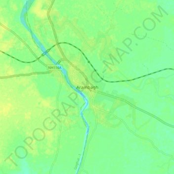
Name: Arambagh topographic map, elevation, terrain.

Location: Arambagh, Arambag, Hooghly District, West Bengal, 712600, India (22.83659 87.75086 22.91659 87.83086)

Average elevation: 56 ft

Minimum elevation: 26 ft

Maximum elevation: 82 ft

Other topographic maps

Click on a map to view its topography, its elevation and its terrain.

Arambag

India > West Bengal > Arambag

Average elevation: 49 ft

Gear up for your next adventure:

🪶Compact Camp Shovel - Folding shovel for campsite tasks
🧭Compass with Lanyard - Easy‑carry compass for navigation
🗃️Trail First Aid Kit - Essential kit for outdoor injuries and emergencies
🔭Telescopic Hiking Pole - Adjustable pole for hiking stability
🧼Biodegradable Camping Soap - Eco‑friendly soap for outdoor hygiene

As an Amazon Associate, this site earns from qualifying purchases at no extra cost to you.