
Larmor-Plage topographic map
Interactive map
Click on the map to display elevation.
Larmor-Plage
Les altitudes du finage communal vont du niveau de la mer jusqu'à 35 mètres ( dans l'angle nord-ouest du territoire communal, près de "La Vraie Croix").
About this map
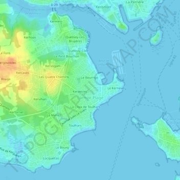
Name: Larmor-Plage topographic map, elevation, terrain.
Average elevation: 20 ft
Minimum elevation: -3 ft
Maximum elevation: 118 ft