Geolocate

Paola topographic map

Click on the map to display elevation.

About this map

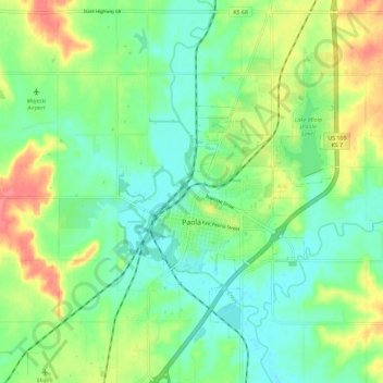
Name: Paola topographic map, elevation, terrain.

Location: Paola, Miami County, Kansas, United States (38.53475 -94.89359 38.62406 -94.83464)

Average elevation: 919 ft

Minimum elevation: 837 ft

Maximum elevation: 1,070 ft

Miami County trails, hiking, mountain biking, running and outdoor activities

Other topographic maps

Click on a map to view its topography, its elevation and its terrain.

Beagle

United States > Kansas > Miami County

Average elevation: 955 ft

Somerset

United States > Kansas > Miami County

Average elevation: 948 ft

Spring Hill

United States > Kansas > Miami County > Spring Hill

Average elevation: 1,050 ft

Gear up for your next adventure:

🔌Solar Panel Charger - Charge gear sustainably outdoors
📷Action Camera - Capture your outdoor adventures in HD
🔦Powerful Headlamps - Ultra-bright hands-free lighting for night navigation
🛡️Bear Spray Outdoor - Protection in bear country hikes
🔌USB Car Charger - Car charger for on‑the‑go power needs

As an Amazon Associate, this site earns from qualifying purchases at no extra cost to you.