
Derry topographic map
Click on the map to display elevation.
About this map
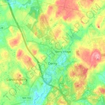
Name: Derry topographic map, elevation, terrain.
Average elevation: 364 ft
Minimum elevation: 207 ft
Maximum elevation: 594 ft
Rockingham County trails, hiking, mountain biking, running and outdoor activities
Other topographic maps
Click on a map to view its topography, its elevation and its terrain.
South Beacon Shoal
United States > New Hampshire > Rockingham County > Portsmouth
Average elevation: 13 ft
Hampton River
United States > New Hampshire > Rockingham County > Hampton Falls
Average elevation: 3 ft
Providence Hill
United States > New Hampshire > Rockingham County > Atkinson
Average elevation: 236 ft
Salem Depot
United States > New Hampshire > Rockingham County > Salem > Salem Depot
Average elevation: 164 ft
Rye Beach Village District
United States > New Hampshire > Rockingham County > Rye Beach Village District
Average elevation: 23 ft