Geolocate

Mount Cleveland topographic map

Click on the map to display elevation.

Mount Cleveland

While not of great absolute elevation (the mountain is more than 2,300 ft (700 m) lower than Granite Peak, the highest peak in Montana), Mount Cleveland is notable for its large, steep rise above local terrain. For example, its west flank rises over 5,500 ft (1,700 m) in less than 2 mi (3.2 km); the northwest face, the steepest on the mountain, rises 4,000 ft (1,200 m) in less than 0.4 mi (0.64 km). The other faces show almost as much vertical relief. This scale and steepness of relief is quite rare in the contiguous United States. Mount Cleveland ranks 50th on the list of peaks in the contiguous U.S. with the greatest topographic prominence. The massif upon which Mount Cleveland is situated also includes 10,001-foot (3,048 m) Kaiser Point, which is the seventh-highest peak in the park and is only .67 mi (1.08 km) to the northeast.

Wikipedia (CC-BY-SA 3.0)

About this map

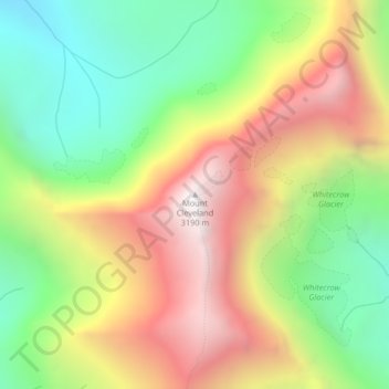
Name: Mount Cleveland topographic map, elevation, terrain.

Location: Mount Cleveland, Glacier County, Montana, United States (48.92495 -113.84811 48.92505 -113.84801)

Average elevation: 7,674 ft

Minimum elevation: 5,377 ft

Maximum elevation: 10,410 ft

Glacier County trails, hiking, mountain biking, running and outdoor activities

Other topographic maps

Click on a map to view its topography, its elevation and its terrain.

Grinnell Glacier

United States > Montana > Glacier County

Average elevation: 6,998 ft

Hidden Lake

United States > Montana > Glacier County

Average elevation: 4,646 ft

Gem Glacier

United States > Montana > Glacier County

Average elevation: 7,054 ft

Swiftcurrent Glacier

United States > Montana > Glacier County

Average elevation: 6,765 ft

Logan Glacier

United States > Montana > Glacier County

Average elevation: 7,323 ft

Blackfoot Glacier

United States > Montana > Glacier County

Average elevation: 7,598 ft

Jackson Glacier

United States > Montana > Glacier County

Average elevation: 7,441 ft

Iceberg Lake

United States > Montana > Glacier County

Average elevation: 7,096 ft

Hope Lake

United States > Montana > Glacier County

Average elevation: 3,868 ft

Lake Josephine

United States > Montana > Glacier County

Average elevation: 5,630 ft

Browning

United States > Montana > Glacier County

Average elevation: 4,390 ft

Logan Glacier

United States > Montana > Glacier County

Average elevation: 7,323 ft

Pray Lake

United States > Montana > Glacier County

Average elevation: 5,633 ft

Gear up for your next adventure:

🚗GPS Dash Cams - Record your scenic drives through mountain passes and canyons
Backpacking Tent - Lightweight and durable tent for multi‑day hikes
🏕️Tent Footprint - Protect your tent base from wear
📻Weather Alert Radios - Stay informed of storm risks while off-the-grid
🗺️NatGeo Topo Maps - High-quality waterproof printed topographic maps of US Parks

As an Amazon Associate, this site earns from qualifying purchases at no extra cost to you.