
Spring Hill topographic map
Click on the map to display elevation.
About this map
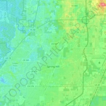
Name: Spring Hill topographic map, elevation, terrain.
Location: Spring Hill, Hernando County, Florida, United States (28.43357 -82.63986 28.53395 -82.45859)
Average elevation: 59 ft
Minimum elevation: 0 ft
Maximum elevation: 236 ft
Hernando County trails, hiking, mountain biking, running and outdoor activities
Other topographic maps
Click on a map to view its topography, its elevation and its terrain.