
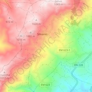
Silvares topographic map
Interactive map
Click on the map to display elevation.
About this map
Name: Silvares topographic map, elevation, terrain.
Average elevation: 2,356 ft
Minimum elevation: 1,122 ft
Maximum elevation: 3,369 ft
Other topographic maps
Click on a map to view its topography, its elevation and its terrain.
Caparrosa
Portugal > Centro > U.F Caparrosa e Silvares > Tondela
Caparrosa, U.F Caparrosa e Silvares, Tondela, Viseu, Viseu Dão-Lafões, Centro, Portugal
Average elevation: 1,542 ft