
Make a donation
Gear up for your next adventure:
As an Amazon Associate, this site earns from qualifying purchases at no extra cost to you.
Honesdale topographic map
Click on the map to display elevation.
Make a donation
Gear up for your next adventure:
As an Amazon Associate, this site earns from qualifying purchases at no extra cost to you.
About this map
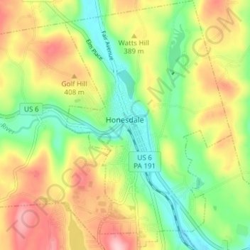
Name: Honesdale topographic map, elevation, terrain.
Location: Honesdale, Wayne County, Pennsylvania, 18431, United States (41.55261 -75.27300 41.59800 -75.23246)
Average elevation: 1,198 ft
Minimum elevation: 928 ft
Maximum elevation: 1,549 ft
Wayne County trails, hiking, mountain biking, running and outdoor activities
Make a donation
Gear up for your next adventure:
As an Amazon Associate, this site earns from qualifying purchases at no extra cost to you.
Other topographic maps
Click on a map to view its topography, its elevation and its terrain.
Newfoundland
United States > Pennsylvania > Wayne County > Dreher Township
Average elevation: 1,496 ft
Make a donation
Gear up for your next adventure:
As an Amazon Associate, this site earns from qualifying purchases at no extra cost to you.
Make a donation
Gear up for your next adventure:
As an Amazon Associate, this site earns from qualifying purchases at no extra cost to you.
Equinunk
United States > Pennsylvania > Wayne County > Manchester Township
Average elevation: 1,191 ft
Make a donation
Gear up for your next adventure:
As an Amazon Associate, this site earns from qualifying purchases at no extra cost to you.
Cascade
United States > Pennsylvania > Wayne County > Mount Pleasant Township
Average elevation: 1,585 ft
Make a donation
Gear up for your next adventure:
As an Amazon Associate, this site earns from qualifying purchases at no extra cost to you.
Forest City Station
United States > Pennsylvania > Wayne County > Clinton Township
Average elevation: 1,742 ft
Make a donation
Gear up for your next adventure:
As an Amazon Associate, this site earns from qualifying purchases at no extra cost to you.