
Lapine topographic map
Interactive map
Click on the map to display elevation.
About this map
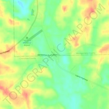
Name: Lapine topographic map, elevation, terrain.
Location: Lapine, Montgomery County, Alabama, United States (31.94571 -86.30441 31.98571 -86.26441)
Average elevation: 456 ft
Minimum elevation: 367 ft
Maximum elevation: 551 ft
Other topographic maps
Click on a map to view its topography, its elevation and its terrain.
Cloverland
United States > Alabama > Montgomery County > Montgomery
Cloverland, Montgomery, Montgomery County, Alabama, 36104, United States
Average elevation: 220 ft
Johnstown East
United States > Alabama > Montgomery County > Montgomery
Johnstown East, Montgomery, Montgomery County, Alabama, 36109, United States
Average elevation: 240 ft
Montgomery
United States > Alabama > Montgomery County
Montgomery, Montgomery County, Alabama, United States
Average elevation: 210 ft
Flatwood
United States > Alabama > Montgomery County
Flatwood, Montgomery County, Alabama, 36110, United States
Average elevation: 161 ft
Cooks
United States > Alabama > Montgomery County
Cooks, Montgomery County, Alabama, 36124, United States
Average elevation: 167 ft
Landmarks
United States > Alabama > Montgomery County > Montgomery > Landmarks
Landmarks, Montgomery, Montgomery County, Alabama, 36119, United States
Average elevation: 236 ft