
Kuhistoni Mastchoh District topographic map
Interactive map
Click on the map to display elevation.
About this map
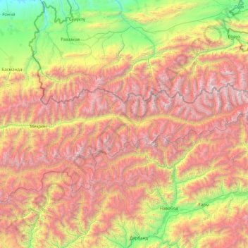
Name: Kuhistoni Mastchoh District topographic map, elevation, terrain.
Location: Kuhistoni Mastchoh District, Sughd Region, Tajikistan (39.22428 69.11790 39.62208 70.69404)
Average elevation: 8,947 ft
Minimum elevation: 2,382 ft
Maximum elevation: 17,641 ft
Other topographic maps
Click on a map to view its topography, its elevation and its terrain.
Jomi
Tajikistan > Sughd Region > Zafarobod District
Jomi, Zafarobod District, Sughd Region, Tajikistan
Average elevation: 1,345 ft