
Thank you for supporting this site ❤️
Make a donation
Make a donation
Gear up for your next adventure:
As an Amazon Associate, this site earns from qualifying purchases at no extra cost to you.
Velp topographic map
Click on the map to display elevation.
Thank you for supporting this site ❤️
Make a donation
Make a donation
Gear up for your next adventure:
As an Amazon Associate, this site earns from qualifying purchases at no extra cost to you.
About this map
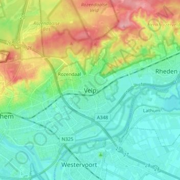
Name: Velp topographic map, elevation, terrain.
Location: Velp, Gelderland, Nederland, 6881HJ, Nederland (51.95587 5.93513 52.03587 6.01513)
Average elevation: 112 ft
Minimum elevation: 13 ft
Maximum elevation: 348 ft
Thank you for supporting this site ❤️
Make a donation
Make a donation
Gear up for your next adventure:
As an Amazon Associate, this site earns from qualifying purchases at no extra cost to you.