
Make a donation
Gear up for your next adventure:
As an Amazon Associate, this site earns from qualifying purchases at no extra cost to you.
Cuerdale topographic map
Click on the map to display elevation.
Make a donation
Gear up for your next adventure:
As an Amazon Associate, this site earns from qualifying purchases at no extra cost to you.
About this map
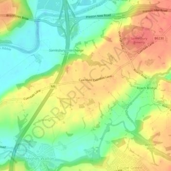
Name: Cuerdale topographic map, elevation, terrain.
Average elevation: 115 ft
Minimum elevation: 23 ft
Maximum elevation: 207 ft
Make a donation
Gear up for your next adventure:
As an Amazon Associate, this site earns from qualifying purchases at no extra cost to you.
Other topographic maps
Click on a map to view its topography, its elevation and its terrain.
Walton Summit
United Kingdom > England > Lancashire > South Ribble > Bamber Bridge
Average elevation: 220 ft
Make a donation
Gear up for your next adventure:
As an Amazon Associate, this site earns from qualifying purchases at no extra cost to you.
Roach Bridge
United Kingdom > England > Lancashire > South Ribble > Coupe Green
Average elevation: 161 ft
Make a donation
Gear up for your next adventure:
As an Amazon Associate, this site earns from qualifying purchases at no extra cost to you.