
Pocono Summit topographic map
Click on the map to display elevation.
About this map
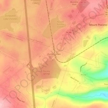
Name: Pocono Summit topographic map, elevation, terrain.
Average elevation: 1,804 ft
Minimum elevation: 1,460 ft
Maximum elevation: 1,942 ft
Monroe County trails, hiking, mountain biking, running and outdoor activities
Other topographic maps
Click on a map to view its topography, its elevation and its terrain.
Pocono Pines
United States > Pennsylvania > Monroe County > Tobyhanna Township > Pocono Pines
Average elevation: 1,824 ft
Emerald Lakes
United States > Pennsylvania > Monroe County > Tobyhanna Township > Emerald Lakes
Average elevation: 1,896 ft
Pocono Lake
United States > Pennsylvania > Monroe County > Tobyhanna Township > Pocono Pines
Average elevation: 1,762 ft
Pocono Pines
United States > Pennsylvania > Monroe County > Tobyhanna Township
Average elevation: 1,824 ft