
Make a donation
Gear up for your next adventure:
As an Amazon Associate, this site earns from qualifying purchases at no extra cost to you.
Boreas Pass topographic map
Click on the map to display elevation.
Make a donation
Gear up for your next adventure:
As an Amazon Associate, this site earns from qualifying purchases at no extra cost to you.
Boreas Pass
Boreas Pass (elevation 11,481 ft (3,499 m)) is a high mountain pass in central Colorado, in the Rocky Mountains of the western United States. The pass is located on the continental divide, at the crest of the Front Range along the border between Park (south) and Summit counties.
Make a donation
Gear up for your next adventure:
As an Amazon Associate, this site earns from qualifying purchases at no extra cost to you.
About this map
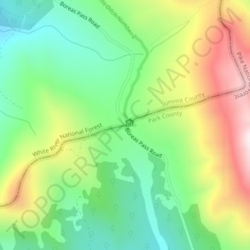
Name: Boreas Pass topographic map, elevation, terrain.
Location: Boreas Pass, Summit County, Colorado, United States (39.41034 -105.96849 39.41044 -105.96839)
Average elevation: 11,677 ft
Minimum elevation: 10,863 ft
Maximum elevation: 12,933 ft
Summit County trails, hiking, mountain biking, running and outdoor activities
Make a donation
Gear up for your next adventure:
As an Amazon Associate, this site earns from qualifying purchases at no extra cost to you.
Other topographic maps
Click on a map to view its topography, its elevation and its terrain.