Geolocate

Mayabon topographic map

Click on the map to display elevation.

About this map

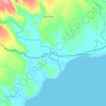
Name: Mayabon topographic map, elevation, terrain.

Location: Mayabon, Negros Oriental, Central Visayas, 6218, Philippines (9.07603 123.15223 9.11603 123.19223)

Average elevation: 98 ft

Minimum elevation: 0 ft

Maximum elevation: 453 ft

Other topographic maps

Click on a map to view its topography, its elevation and its terrain.

La Paz

Philippines > Negros Oriental > Bais

Average elevation: 49 ft

Sibulan

Philippines > Negros Oriental

Average elevation: 712 ft

Cantil-e

Philippines > Negros Oriental > Dumaguete

Average elevation: 253 ft

Lake Balinsasayao

Philippines > Negros Oriental > Sibulan

Average elevation: 3,169 ft

Gear up for your next adventure:

🎒Outdoor Daypacks - Lightweight backpacks designed for carrying maps and essential gear
🪶Fire Starter Kit - Reliable fire starter for survival and camping
🥩Freeze-Dried Meals - Nutritious and lightweight food for remote expeditions
📻Weather Alert Radios - Stay informed of storm risks while off-the-grid
🛡️Insect Repellent - Protection against bugs during outdoor activities

As an Amazon Associate, this site earns from qualifying purchases at no extra cost to you.