
Make a donation
Gear up for your next adventure:
As an Amazon Associate, this site earns from qualifying purchases at no extra cost to you.
District 9 topographic map
Click on the map to display elevation.
Make a donation
Gear up for your next adventure:
As an Amazon Associate, this site earns from qualifying purchases at no extra cost to you.
About this map
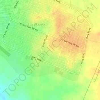
Name: District 9 topographic map, elevation, terrain.
Average elevation: 2,152 ft
Minimum elevation: 2,090 ft
Maximum elevation: 2,192 ft
Make a donation
Gear up for your next adventure:
As an Amazon Associate, this site earns from qualifying purchases at no extra cost to you.
Other topographic maps
Click on a map to view its topography, its elevation and its terrain.
Al Zaatari Refugee Camp
Jordan > Mafraq > Badiah Shamaliyah Gharbiyah Sub-District
Average elevation: 2,149 ft
Thughrat al Jubb
Jordan > Mafraq > Badiah Shamaliyah Gharbiyah Sub-District
Average elevation: 2,244 ft
Make a donation
Gear up for your next adventure:
As an Amazon Associate, this site earns from qualifying purchases at no extra cost to you.