
Mossy Creek topographic map
Interactive map
Click on the map to display elevation.
About this map
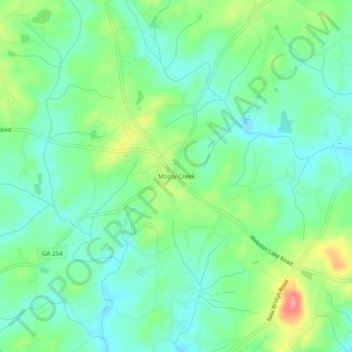
Name: Mossy Creek topographic map, elevation, terrain.
Location: Mossy Creek, White County, Georgia, United States (34.52121 -83.70546 34.56121 -83.66546)
Average elevation: 1,365 ft
Minimum elevation: 1,280 ft
Maximum elevation: 1,549 ft
Other topographic maps
Click on a map to view its topography, its elevation and its terrain.
Helen
United States > Georgia > White County
Helen, White County, Georgia, 30545, United States
Average elevation: 1,601 ft
Unicoi Lake
United States > Georgia > White County
Unicoi Lake, White County, Georgia, United States
Average elevation: 1,844 ft
Nacoochee
United States > Georgia > White County
Nacoochee, White County, Georgia, 30545, United States
Average elevation: 1,473 ft
Raven Cliff Falls
United States > Georgia > White County
Raven Cliff Falls, White County, Georgia, United States
Average elevation: 3,025 ft
Cleveland
United States > Georgia > White County
Cleveland, White County, Georgia, 30528, United States
Average elevation: 1,572 ft
Sautee
United States > Georgia > White County
Sautee, White County, Georgia, 30571, United States
Average elevation: 1,447 ft
Yonah Mountain
United States > Georgia > White County
Yonah Mountain, White County, Georgia, United States
Average elevation: 2,031 ft
Smithgall Woods State Park
United States > Georgia > White County
Smithgall Woods State Park, White County, Georgia, United States
Average elevation: 2,008 ft