Geolocate

Acora topographic map

Click on the map to display elevation.

About this map

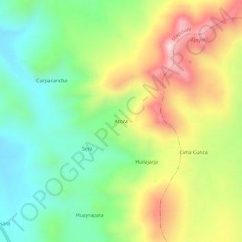
Name: Acora topographic map, elevation, terrain.

Location: Acora, Macusani, Carabaya, Puno, Perú (-14.11237 -70.36189 -14.07237 -70.32189)

Average elevation: 15,253 ft

Minimum elevation: 14,567 ft

Maximum elevation: 16,263 ft

Other topographic maps

Click on a map to view its topography, its elevation and its terrain.

Macusani

Perú > Puno > Macusani

Average elevation: 14,790 ft

Gear up for your next adventure:

🩹Survival Bandages - High‑quality bandages for emergencies
🕶️GPS Smartphone Mount - Secure mount for phone navigation
💧Water Purification System - Clean water on the trail with reliable purifiers
📡GPS Antenna Upgrade - Enhance GPS reception in remote terrain
🪑Portable Camp Table - Compact table for campsite meals

As an Amazon Associate, this site earns from qualifying purchases at no extra cost to you.