
Make a donation
Gear up for your next adventure:
As an Amazon Associate, this site earns from qualifying purchases at no extra cost to you.
San Miniato topographic map
Click on the map to display elevation.
Make a donation
Gear up for your next adventure:
As an Amazon Associate, this site earns from qualifying purchases at no extra cost to you.
San Miniato
San Miniato has a railway station on the Pisa-Florence line. Due to topography the line lies on the flat plain to the north, around 4km from the town centre. A local bus links the station to the hilltop town.
Make a donation
Gear up for your next adventure:
As an Amazon Associate, this site earns from qualifying purchases at no extra cost to you.
About this map
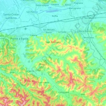
Name: San Miniato topographic map, elevation, terrain.
Location: San Miniato, Pisa, Tuscany, Italy (43.61418 10.76292 43.71939 10.93409)
Average elevation: 226 ft
Minimum elevation: 33 ft
Maximum elevation: 758 ft
Make a donation
Gear up for your next adventure:
As an Amazon Associate, this site earns from qualifying purchases at no extra cost to you.