Geolocate
👉 Easily get elevation data in JSON, GeoTIFF and KML formats using Elevation API
Thank you for supporting this site ❤️
Make a donation

Ellenton topographic map

Click on the map to display elevation.

👉 Easily get elevation data in JSON, GeoTIFF and KML formats using Elevation API
Thank you for supporting this site ❤️
Make a donation

About this map

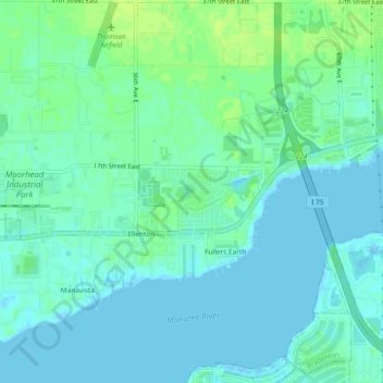
Name: Ellenton topographic map, elevation, terrain.

Location: Ellenton, Manatee County, Florida, United States (27.50552 -82.55195 27.54696 -82.50569)

Average elevation: 16 ft

Minimum elevation: -7 ft

Maximum elevation: 43 ft

Manatee County trails, hiking, mountain biking, running and outdoor activities

Gear up for your next adventure:

🔭Compact Binoculars - HD vision for scouting terrain and identifying distant landmarks
🎒Trail Energy Bars - High‑calorie bars for hiking energy
🚑Emergency Bivvies - Heat-reflective sleeping bags for survival situations
🧭Hiking Compass - Precision compass for reliable navigation in the wilderness
🌄Hiking Binoculars - Compact binoculars for scenic views and trail spotting

As an Amazon Associate, this site earns from qualifying purchases at no extra cost to you.