Geolocate

Coles Bay topographic map

Click on the map to display elevation.

About this map

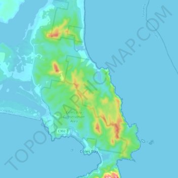
Name: Coles Bay topographic map, elevation, terrain.

Location: Coles Bay, Glamorgan-Spring Bay, Tasmania, 7251, Australia (-42.14703 148.15294 -42.00144 148.34540)

Average elevation: 85 ft

Minimum elevation: -3 ft

Maximum elevation: 1,227 ft

Other topographic maps

Click on a map to view its topography, its elevation and its terrain.

Cathedral Mountain

Australia > Tasmania

Average elevation: 3,255 ft

The Nut

Australia > Tasmania > Stanley

Average elevation: 26 ft

Waterworks Reserve

Australia > Tasmania > Hobart

Average elevation: 787 ft

Rowlands Hill

Australia > Tasmania

Average elevation: 1,273 ft

Bream Creek

Australia > Tasmania > Bream Creek

Average elevation: 115 ft

Cradle Mountain

Australia > Tasmania > Cradle Mountain

Average elevation: 3,753 ft

West Gawler River

Australia > Tasmania > Sprent > Gawler

Average elevation: 659 ft

Mount Patrick

Australia > Tasmania

Average elevation: 2,831 ft

Mount Tyndall

Australia > Tasmania

Average elevation: 2,986 ft

Mount Ossa

Australia > Tasmania

Average elevation: 3,996 ft

Gear up for your next adventure:

🏔️Mountain Trail Maps - High‑detail maps for popular peaks
🛡️Insect Repellent - Protection against bugs during outdoor activities
🗺️Topographic Maps - Detailed topo maps for hiking, exploring and outdoor navigation
🪓Survival Multi‑Tool - Versatile tool for camp and trail tasks
📡Handheld GPS Device - Reliable handheld GPS for outdoor navigation

As an Amazon Associate, this site earns from qualifying purchases at no extra cost to you.