
Make a donation
Gear up for your next adventure:
As an Amazon Associate, this site earns from qualifying purchases at no extra cost to you.
Vroenhoven topographic map
Click on the map to display elevation.
Make a donation
Gear up for your next adventure:
As an Amazon Associate, this site earns from qualifying purchases at no extra cost to you.
Vroenhoven
Vroenhoven bestaat uit twee delen. Aan de westzijde van het Albertkanaal ligt de dorpskern. Hier bevindt zich de Sint-Petrus en Pauluskerk. Vroenhoven (kerk) ligt op een hoogte van 90 meter boven zeeniveau.
Make a donation
Gear up for your next adventure:
As an Amazon Associate, this site earns from qualifying purchases at no extra cost to you.
About this map
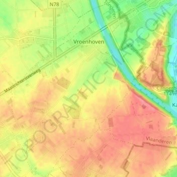
Name: Vroenhoven topographic map, elevation, terrain.
Location: Vroenhoven, Riemst, Tongeren, Limburg, Vlaanderen, België (50.79833 5.61013 50.83713 5.65646)
Average elevation: 315 ft
Minimum elevation: 180 ft
Maximum elevation: 407 ft
Make a donation
Gear up for your next adventure:
As an Amazon Associate, this site earns from qualifying purchases at no extra cost to you.