
River Teith topographic map
Interactive map
Click on the map to display elevation.
About this map
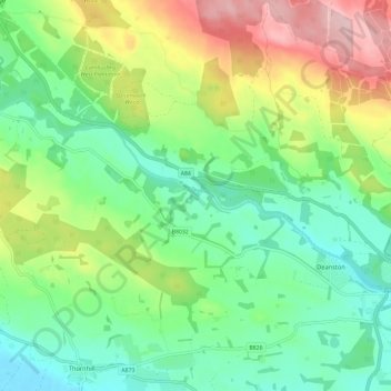
Name: River Teith topographic map, elevation, terrain.
Location: River Teith, Stirling, Scotland, FK16 6AH, United Kingdom (56.18655 -4.17821 56.21883 -4.06054)
Average elevation: 305 ft
Minimum elevation: 39 ft
Maximum elevation: 817 ft
Other topographic maps
Click on a map to view its topography, its elevation and its terrain.
Port of Menteith
United Kingdom > Scotland > Stirling > Port of Menteith
Port of Menteith, Stirling, Scotland, FK8 3RB, United Kingdom
Average elevation: 331 ft
Ardoch Burn
United Kingdom > Scotland > Stirling
Ardoch Burn, Stirling, Scotland, FK16 6EQ, United Kingdom
Average elevation: 738 ft
Garbh Uisge
United Kingdom > Scotland > Stirling
Garbh Uisge, Stirling, Scotland, FK17 8AW, United Kingdom
Average elevation: 430 ft