
Thank you for supporting this site ❤️
Make a donation
Make a donation
Gear up for your next adventure:
As an Amazon Associate, this site earns from qualifying purchases at no extra cost to you.
Kasdir topographic map
Click on the map to display elevation.
Thank you for supporting this site ❤️
Make a donation
Make a donation
Gear up for your next adventure:
As an Amazon Associate, this site earns from qualifying purchases at no extra cost to you.
About this map
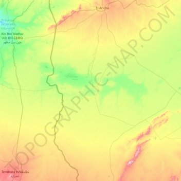
Name: Kasdir topographic map, elevation, terrain.
Location: Kasdir, daïra Makman Ben Amer, Naâma, Algérie (32.99897 -1.73248 34.27991 -0.94892)
Average elevation: 3,753 ft
Minimum elevation: 2,861 ft
Maximum elevation: 5,869 ft
Thank you for supporting this site ❤️
Make a donation
Make a donation
Gear up for your next adventure:
As an Amazon Associate, this site earns from qualifying purchases at no extra cost to you.
Other topographic maps
Click on a map to view its topography, its elevation and its terrain.
Makmen Ben Amer
Algérie > Naâma > daïra Makman Ben Amer > Makman Ben Ammar
Average elevation: 3,507 ft