
Make a donation
Gear up for your next adventure:
As an Amazon Associate, this site earns from qualifying purchases at no extra cost to you.
Greenfield topographic map
Click on the map to display elevation.
Make a donation
Gear up for your next adventure:
As an Amazon Associate, this site earns from qualifying purchases at no extra cost to you.
Greenfield
According to the United States Census Bureau, the town has a total area of 26.8 square miles (69.3 km2), of which 26.2 square miles (67.9 km2) are land and 0.54 square miles (1.4 km2) are water, comprising 2.04% of the town. The southeast part of Greenfield is drained by Stony Brook, flowing southeast to the Souhegan River in Wilton, while the western part, including the town center, is drained by the Contoocook River and its tributary Otter Brook; the Contoocook forms the northwest border of the town, where it passes through Powder Mill Pond. The northeast corner of the town is drained by Rand Brook, a tributary of the South Branch of the Piscataquog River. Greenfield lies fully within the Merrimack River watershed. North Pack Monadnock, elevation 2,276 feet (694 m) above sea level, is the northernmost summit of the Wapack Range and the highest point in Greenfield, located in the extreme south part of the town.
Make a donation
Gear up for your next adventure:
As an Amazon Associate, this site earns from qualifying purchases at no extra cost to you.
About this map
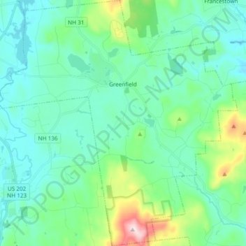
Name: Greenfield topographic map, elevation, terrain.
Average elevation: 945 ft
Minimum elevation: 640 ft
Maximum elevation: 2,231 ft
Make a donation
Gear up for your next adventure:
As an Amazon Associate, this site earns from qualifying purchases at no extra cost to you.