
West Van Lear topographic map
Interactive map
Click on the map to display elevation.
About this map
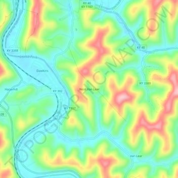
Name: West Van Lear topographic map, elevation, terrain.
Average elevation: 794 ft
Minimum elevation: 577 ft
Maximum elevation: 1,168 ft
Other topographic maps
Click on a map to view its topography, its elevation and its terrain.
Paintsville Lake State Park
United States > Kentucky > Johnson County
Paintsville Lake State Park, Johnson County, Kentucky, United States
Average elevation: 791 ft
Paintsville
United States > Kentucky > Johnson County
Paintsville, Johnson County, Kentucky, 41240, United States
Average elevation: 797 ft
Paintsville
United States > Kentucky > Johnson County > Paintsville > Paintsville
Paintsville, Johnson County, Kentucky, 41240, United States
Average elevation: 797 ft
Sitka
United States > Kentucky > Johnson County
Sitka, Johnson County, Kentucky, 41255, United States
Average elevation: 899 ft
Volga
United States > Kentucky > Johnson County > Volga
Volga, Johnson County, Kentucky, 41255, United States
Average elevation: 876 ft
Staffordsville
United States > Kentucky > Johnson County
Staffordsville, Johnson County, Kentucky, 41256, United States
Average elevation: 781 ft
Paintsville Lake
United States > Kentucky > Johnson County
Paintsville Lake, Johnson County, Kentucky, United States
Average elevation: 935 ft
Dawkins
United States > Kentucky > Johnson County
Dawkins, Johnson County, Kentucky, 41268, United States
Average elevation: 781 ft