
Make a donation
Gear up for your next adventure:
As an Amazon Associate, this site earns from qualifying purchases at no extra cost to you.
Ellmau topographic map
Click on the map to display elevation.
Make a donation
Gear up for your next adventure:
As an Amazon Associate, this site earns from qualifying purchases at no extra cost to you.
Ellmau
Ellmau is a municipality in the district of Kufstein in the Austrian region of Sölllandl. It lies 12 km southeast of Kufstein and 9 km west of Sankt Johann in Tirol. It is located at an elevation of 820 m above sea level. It was mentioned for the first time in the records in 1155 and is nowadays part of the Ski Welt skiing area.
Make a donation
Gear up for your next adventure:
As an Amazon Associate, this site earns from qualifying purchases at no extra cost to you.
About this map
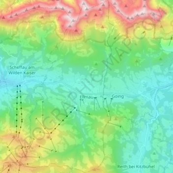
Name: Ellmau topographic map, elevation, terrain.
Location: Ellmau, Bezirk Kufstein, Tyrol, 6352, Austria (47.47244 12.24877 47.56612 12.32473)
Average elevation: 3,780 ft
Minimum elevation: 2,087 ft
Maximum elevation: 7,585 ft
Make a donation
Gear up for your next adventure:
As an Amazon Associate, this site earns from qualifying purchases at no extra cost to you.
Other topographic maps
Click on a map to view its topography, its elevation and its terrain.
Make a donation
Gear up for your next adventure:
As an Amazon Associate, this site earns from qualifying purchases at no extra cost to you.
Make a donation
Gear up for your next adventure:
As an Amazon Associate, this site earns from qualifying purchases at no extra cost to you.