
Make a donation
Gear up for your next adventure:
As an Amazon Associate, this site earns from qualifying purchases at no extra cost to you.
Boekhoute topographic map
Click on the map to display elevation.
Make a donation
Gear up for your next adventure:
As an Amazon Associate, this site earns from qualifying purchases at no extra cost to you.
Boekhoute
Boekhoute ligt in het Vlaamse poldergebied op een hoogte van 3-4 meter. Kunstmatige waterlopen zijn het Leopoldkanaal en het Isabellakanaal, waarmee de afwatering van de polders wordt verzorgd. Meer natuurlijke waterlopen zijn de Vliet en de Basseveldse Beek. In het verlengde van het Leopoldkanaal ligt bovendien de Zwarte Sluisbeek, welke parallel aan de Belgisch-Nederlandse grens loopt.
Make a donation
Gear up for your next adventure:
As an Amazon Associate, this site earns from qualifying purchases at no extra cost to you.
About this map
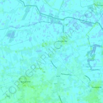
Name: Boekhoute topographic map, elevation, terrain.
Average elevation: 7 ft
Minimum elevation: -13 ft
Maximum elevation: 23 ft
Make a donation
Gear up for your next adventure:
As an Amazon Associate, this site earns from qualifying purchases at no extra cost to you.
Other topographic maps
Click on a map to view its topography, its elevation and its terrain.