
Make a donation
Gear up for your next adventure:
As an Amazon Associate, this site earns from qualifying purchases at no extra cost to you.
Alveringem topographic map
Click on the map to display elevation.
Make a donation
Gear up for your next adventure:
As an Amazon Associate, this site earns from qualifying purchases at no extra cost to you.
Alveringem
Alveringem ligt ten westen van de Lovaart op een hoogte van ongeveer 8 meter.
Make a donation
Gear up for your next adventure:
As an Amazon Associate, this site earns from qualifying purchases at no extra cost to you.
About this map
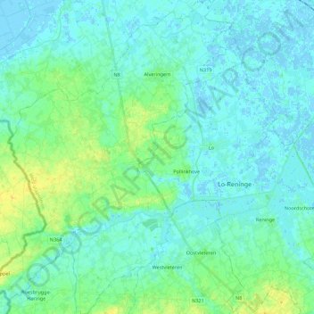
Name: Alveringem topographic map, elevation, terrain.
Location: Alveringem, Veurne, West-Vlaanderen, België (50.90663 2.59017 51.04429 2.77060)
Average elevation: 16 ft
Minimum elevation: -13 ft
Maximum elevation: 62 ft
Make a donation
Gear up for your next adventure:
As an Amazon Associate, this site earns from qualifying purchases at no extra cost to you.
Other topographic maps
Click on a map to view its topography, its elevation and its terrain.