
Make a donation
Gear up for your next adventure:
As an Amazon Associate, this site earns from qualifying purchases at no extra cost to you.
Stäfa topographic map
Click on the map to display elevation.
Make a donation
Gear up for your next adventure:
As an Amazon Associate, this site earns from qualifying purchases at no extra cost to you.
Stäfa
Stäfa (im Ortsdialekt Stääfe [ˈʃtæːfə]) ist eine politische Gemeinde im Kanton Zürich in der Schweiz. Sie liegt am oberen rechten Zürichseeufer – der sogenannten Goldküste – am südöstlichen Ende des Pfannenstiels im Bezirk Meilen im Kanton Zürich. Seine Höhenlage ist zwischen 613 Metern über Meer beim Stäfnertürli und 403 m am Seeufer. Die Gemeinde umfasst die Ortschaften Stäfa, Kehlhof, Uerikon und den Weiler Mutzmalen.
Make a donation
Gear up for your next adventure:
As an Amazon Associate, this site earns from qualifying purchases at no extra cost to you.
About this map
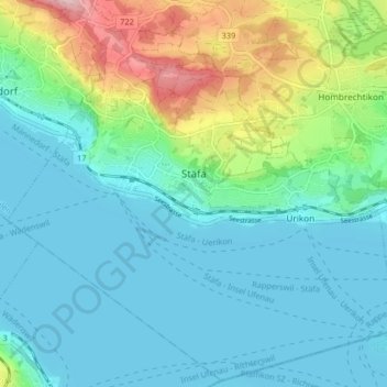
Name: Stäfa topographic map, elevation, terrain.
Location: Stäfa, Bezirk Meilen, Zürich, Schweiz (47.21164 8.69548 47.26518 8.77719)
Average elevation: 1,499 ft
Minimum elevation: 1,319 ft
Maximum elevation: 2,116 ft
Make a donation
Gear up for your next adventure:
As an Amazon Associate, this site earns from qualifying purchases at no extra cost to you.
Other topographic maps
Click on a map to view its topography, its elevation and its terrain.
Make a donation
Gear up for your next adventure:
As an Amazon Associate, this site earns from qualifying purchases at no extra cost to you.