
Make a donation
Gear up for your next adventure:
As an Amazon Associate, this site earns from qualifying purchases at no extra cost to you.
Jeddito topographic map
Click on the map to display elevation.
Make a donation
Gear up for your next adventure:
As an Amazon Associate, this site earns from qualifying purchases at no extra cost to you.
About this map
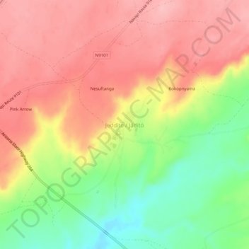
Name: Jeddito topographic map, elevation, terrain.
Average elevation: 6,362 ft
Minimum elevation: 6,109 ft
Maximum elevation: 6,545 ft
Make a donation
Gear up for your next adventure:
As an Amazon Associate, this site earns from qualifying purchases at no extra cost to you.
Other topographic maps
Click on a map to view its topography, its elevation and its terrain.
Show Low
United States > Arizona > Navajo County
Show Low is a city in Navajo County, Arizona. It lies on the Mogollon Rim in east central Arizona, at an elevation of 6,345 feet (1,934 m). The city was established in 1870 and incorporated in 1953. According to the 2010 census, the population of the city was 10,660.
Average elevation: 6,421 ft