
Calatayud topographic map
Interactive map
Click on the map to display elevation.
About this map
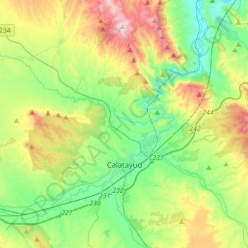
Name: Calatayud topographic map, elevation, terrain.
Average elevation: 2,274 ft
Minimum elevation: 1,378 ft
Maximum elevation: 4,124 ft
Other topographic maps
Click on a map to view its topography, its elevation and its terrain.
Ariza
Spain > Aragon > Comunidad de Calatayud
Ariza, Comunidad de Calatayud, Zaragoza, Aragon, 50220, Spain
Average elevation: 2,628 ft
Mara
Spain > Aragon > Comunidad de Calatayud
Mara, Comunidad de Calatayud, Zaragoza, Aragon, Spain
Average elevation: 2,536 ft
Alhama de Aragón
Spain > Aragon > Comunidad de Calatayud > Alhama de Aragón
Alhama de Aragón, Comunidad de Calatayud, Zaragoza, Aragon, Spain
Average elevation: 2,503 ft
Moros
Spain > Aragon > Comunidad de Calatayud
Moros, Comunidad de Calatayud, Zaragoza, Aragon, Spain
Average elevation: 2,549 ft